Creekwalk revived at council planning retreat – Sedona Red Rock News

Just in time for Christmas, the Sedona City Council considered giving residents a creekwalk.
Deputy City Manager Andy Dickey started the discussion during the council’s Dec. 11 priority retreat session by telling council that the Arizona Department of Transportation had approached the city about selling the city two parcels of land that it currently owns adjacent to State Route 179 and Sombart Lane.
“We’re looking into those at the moment,” Dickey said. “I’ve reached out to a local consultant and just completed a Phase I environmental analysis, and that showed no issues.”
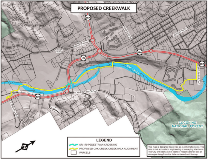
In addition to the city paying ADOT the amount that it originally paid for the parcels, Dickey said, “there would be a deed restriction that requires that the city’s use of them be restricted only to transportation use. I have verified with them that this could be for trails, for potentially some kind of creek park, in this little over-three-acre parcel … As far as the creekwalk goes, this would be a key piece to that walkway. It’s just south of where we just completed the [pedestrian] underpass … the idea would be that in the future a creekwalk could connect between this parcel and 179’s underpass.”
“The idea’s not to create a Slide Rock version 2.0 here, but to restrict use to the area that we want it, and work through our legal department on how we establish restricted zones … and keep folks within the walking path,” Dickey added, a condition that Councilwoman Kathy Kinsella described as “passive recreation only.”
At the other end, Dickey noted that the creekwalk could connect to the new Ambiente: Creekside development off Art Barn Road in Uptown.
“I’ve been told that this connection is something the developer is looking into with the [U.S.] Forest [Service],” Dickey said. “This is a brand-new concept that we’re just putting out at this point.”
Staff is currently looking at moving ahead with creekwalk planning in the coming fiscal year.
“It’s really tremendously exciting to see that,” Councilman Pete Furman said. “We really are going to have think through the management of people … maybe there’s a transit element of access.”
“This is part of this bigger conversation around how do we get around in our city and how do we protect the pieces of our city, including neighborhoods, as people are moving through them,” Councilwoman Melissa Dunn said.
According to city staff’s draft plan, the tentative creekwalk route would run south along the west bank of Oak Creek from Ambiente past the Art Barn, the Arroyo Roble Resort and L’Auberge de Sedona before crossing the creek via a footbridge to the east bank at the in-development Oak Creek Heritage Lodge, traversing the island in the creek across from the Center for the New Age and recrossing the creek again to follow the west bank past Tlaquepaque down to the ADOT parcels.
Historical Background
A system of walking paths along and foot bridges across Oak Creek were proposed as part of the Uptown character area plan in 1993.
In 2007, the city considered an arrangement with Arizona State Parks that would have allowed it to fulfill its obligations under the Sedona Heritage Cultural Park Grant, which provided the city with a grant of $650,000 to be used for the development of the Sedona Cultural Park, by allocating an equivalent value of investment toward the creekwalk project. The city and L’Auberge also discussed an easement for a potential creekwalk during L’Auberge’s rezoning for renovations in 2008.
R.D. Olson Development, developers of the planned Oak Creek Heritage Lodge off Schnebly Hill Road, agreed on Dec. 10 to make a contribution of $550,000 toward the construction of the creekwalk, which will become due when the city funds the remainder of the project, the cost of which was estimated at $5.5 million at the time, up from $1.6 million in November 2014.